
Editor's Note: A tornado watch has been issued for parts of the Chicago area through Wednesday evening. Our weather live blog with updates can be found here. Our original story continues below.
Some parts of the Chicago area Wednesday woke up to rain and heavy downpours, with more showers and storms expected through midday and the possibility of severe weather.
Stream NBC 5 for free, 24/7, wherever you are.
According to NBC 5 Storm Team 5 Meteorologist Alicia Roman, the storms could bring damaging winds, quarter-size hail and possibly even the chance for tornadoes.
As of 5:15 a.m., live weather radar showed rain across northeast Illinois, including in parts of Lake County, Cook County and Chicago. In northwest Indiana, radar showed heavier downpours passing through.
Temperatures Wednesday would be slightly cooler than the 90-degree readings seen Tuesday, with highs in the upper 70s and low 80s. However, dewpoints hitting 70 will make for extremely muggy conditions through the afternoon, Roman said.
The early morning rain was not expected to come with severe weather. Around 12 p.m., stronger showers and storms were expected develop starting in McHenry County and through parts of DeKalb, Aurora and Romeoville. To the south, including in Will, LaSalle and Grundy Counties, even stronger storms will develop, Roman added.
By early afternoon, those storms will move into northwest Indiana, Roman said.

Later in the afternoon, between 3 p.m. and 5 p.m., showers to the west will move eastward.
Feeling out of the loop? We'll catch you up on the news you need to know with the Chicago Catch-Up newsletter.
Stories
"Heavy rain is possible for the afternoon commute," Roman said.
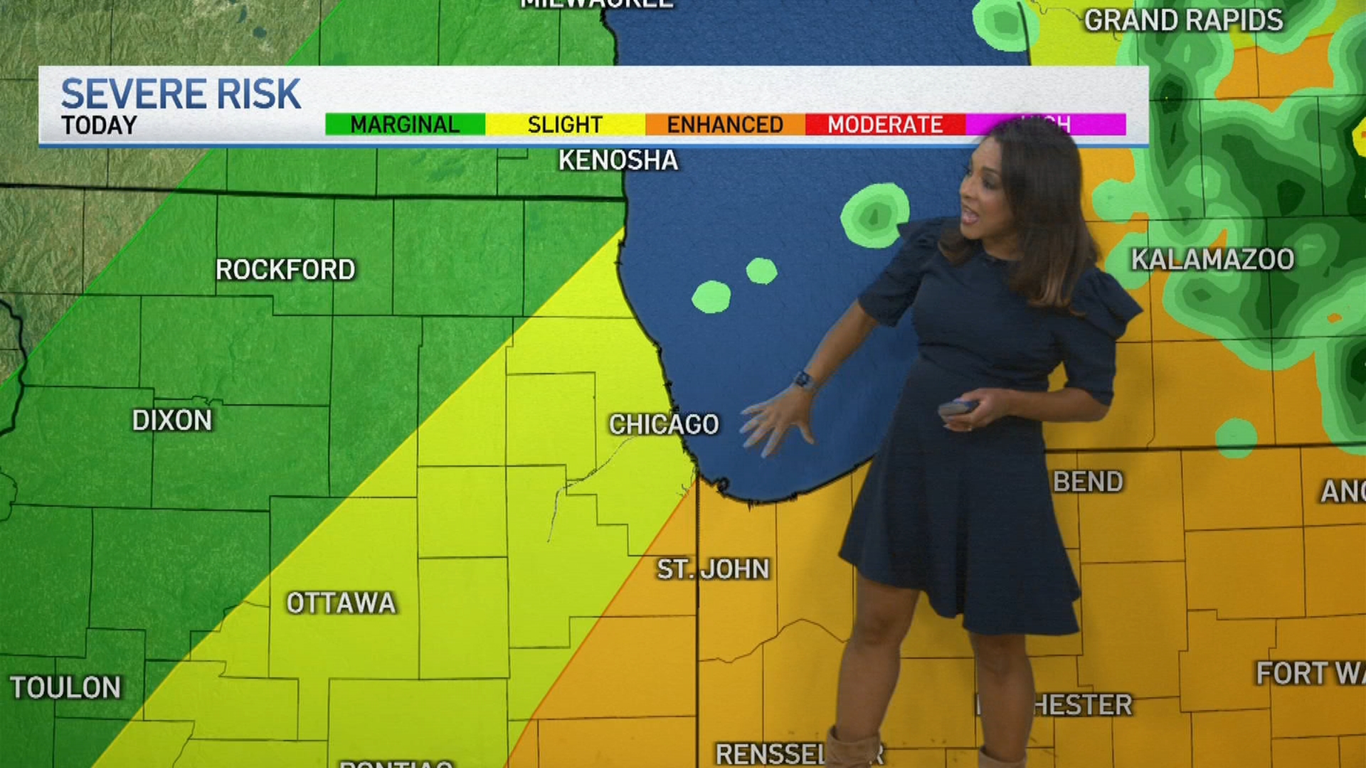
According to the National Weather Service, the entire Chicago area in the late morning through midday will be under a severe weather threat, though the strongest storms may only impact certain parts.
Far north and northwest Lake County will be under a "marginal" risk of severe weather, which ranks as level one of five on the Storm Prediction Center's scale. Parts of southern Lake County, along with Central Cook and areas to the southwest will be under a "slight" risk, which ranks as level two.
In the southeastern counties and in northwest Indiana is where the strongest storms could hit, Roman said, with those parts under an "enhanced" risk of severe weather.
"Some of these storms may be severe, especially along and southeast of I-55 across eastern Illinois and northwest Indiana," the NWS warned. "Damaging winds, large hail and tornadoes are possible, in addition to locally heavy rainfall."
In central Illinois, a tornado watch was issued until 4 p.m. The NWS also issued a flood watch for DuPage, Cook, LaSalle, Kendall, Grundy, Will and Kankakee counties until 8 p.m.

By around 7 p.m., conditions will improve, with storms expected to move out by around 8 p.m.
While temperatures will remain in the low 80s Thursday, extremely muggy and humid conditions will also be in place, making the air feel even warmer.
Heat and humidity levels will increase heading into the weekend, the NWS said, when heat indices could reach 100 degrees or higher, lasting "several days in a row."
As a result, the city of Chicago will activate its emergency cooling centers over the weekend, the Chicago Office of Emergency Management and Communications said.